Search Results for 'Bulteel'
1 results found.
Grattan Road
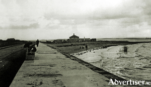
Crane’s Strand or Tráigh na gCorr appears on the 1651 map. It would seem to be the Whitestrand area before the building of Grattan Road. In Dutton’s 1824 survey we read: “It seems to be the general opinion of the oldest inhabitants that for some years past, storms and rains have been more frequent from the west than formerly. (Rice was sown here in 1585). As some corroboration of this idea, the encroachment of the sea near Recorder’s Quay on the west side of Galway, may be adduced, where the marks of the potato ridges may be seen, and where, only a few years ago were in cultivation, though they are now covered at every tide. Lately, the ground near Recorder’s Quay has been reclaimed by Mr Bulteel, and promises to remunerate his very spirited exertion.” (Probably the first ever reclamation of land in Salthill).

